 Paikkatietohakemisto
Population distribution — demography
Type of resources
Available actions
Topics
Keywords
Contact for the resource
Provided by
Representation types
Service types
Scale
-
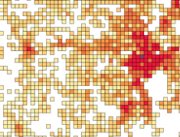
Number of population by 1 km x 1 km grids. The number of population on the last day of the reference year (31 December) by age group. Data includes only inhabited grids. The statistical variables of the data are: Total population (vaesto), number of men (miehet) and women (naiset), under 15 year olds (ika_0_14), 15-64 year olds (ika_15_64), and aged over 65 (ika_65_). Only the number of population is reported for grids of under 10 inhabitants. A grid identifier is expressed using a national identification code derived from the coordinates (idD_nro (num)) and INSPIRE's standard identification code (grd_id (char)). The data also contains the coordinates of the lower left-hand corner of a grid (xkoord, ykoord (num)). The data describes the population distribution independent of administrative areas (such as municipal borders). The data is suitable for examination of population distribution and making various spatial analysis. Data is available as polygons and as centroids of grid cells. The general Terms of Use must be observed when using the data: https://tilastokeskus.fi/org/lainsaadanto/copyright_en.html. In addition to the national version, an INSPIRE information product is also available from the data.
-
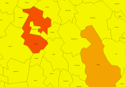
Number of population by statistical units. The number of population on the last day of the reference year (31.12.). Statistical areas are municipalities, sub-regional units, regions, major regions, Regional State Administrative Agencies (AVI) and Centres for Economic Development, Transport and the Environment (ELY). The statistical variables in the data are: total population (vaesto), share of the total population (vaesto_p), number of men (miehet), men's share of the population in an area (miehet_p) and women (naiset), women's share (naiset_p), those aged under 15: number (ika_0_14), share (ika_0_14p), those aged 15 to 64: number (ika_15_64), share (ika_15_64p), and aged 65 or over: number (ika_65_), share (ika_65_p). The data is suitable for the examination of population distribution and making various regional analyses. The general Terms of Use must be observed when using the data: https://tilastokeskus.fi/org/lainsaadanto/copyright_en.html. In addition to the national version, an INSPIRE information product is also available from the data.
-
Number of population by 5 km x 5 km grids. The number of population on the last day of the reference year (31 December) by age group. Data includes only inhabited grids. The statistical variables of the data are: Total population (vaesto), number of men (miehet) and women (naiset), under 15 year olds (ika_0_14), 15–64 year olds (ika_15_64), and aged over 65 (ika_65_). Only the number of population is reported for grids of under 10 inhabitants. A grid identifier is expressed using a national identification code derived from the coordinates (idD_nro (num)) and INSPIRE's standard identification code (grd_id (char)). The data also contains the coordinates of the lower left-hand corner of a grid (xkoord, ykoord (num)). The data describes the population distribution independent of administrative areas (such as municipal borders). The data is suitable for examination of population distribution and making various spatial analysis. The general Terms of Use must be observed when using the data: https://tilastokeskus.fi/org/lainsaadanto/copyright_en.html. In addition to the national version, an INSPIRE information product is also available from the data.
-
Statistics Finland's Web Service is a WMS interface service through which the following data required by INSPIRE and national legislation on geographic information are available: 1) Statistical units: Regional divisions (municipality, major region, region, sub-regional unit, Regional State Administrative Agency (AVI), Centre for Economic Development, Transport and the Environment (ELY), electoral district, working area) and grid 1 km x 1 km. 2) Non-profit and public services: Educational institutions (comprehensive schools, upper secon-dary general schools) 3) Production and industrial facilities: Production and industrial facilities 4) Population distribution by the regional divisions used in statistics and by 1 km x 1 km grids. Other data published: - Open data by postal code area (Paavo) - Population distribution by 5 km x 5 km grids The data are administered by Statistics Finland. The service is free of charge and does not require authentication or identification with a user ID and password. The general Terms of Use must be observed when using the data: http://tilastokeskus.fi/org/lainsaadanto/copyright_en.html.
-
Statistics Finland's INSPIRE data Web Service is a OGC API interface service through which the following data required by INSPIRE and national legislation on geographic information are available: 1) Statistical units: Regional divisions (municipality, major region, region, sub-regional unit, Regional State Administrative Agency (AVI), Centre for Economic Development, Transport and the Environment (ELY), electoral district, working area) and grids 1 km x 1 km and 5 km x 5 km 2) Non-profit and public services: Educational institutions (comprehensive schools, upper secondary general schools) 3) Production and industrial facilities: Production and industrial facilities 4) Population distribution by the regional divisions used in statistics and by 1 km x 1 km and 5 km x 5 km grids. The data are administered by Statistics Finland. The service is free of charge and does not require authentication or identification with a user ID and password. The general Terms of Use must be observed when using the data: http://tilastokeskus.fi/org/lainsaadanto/copyright_en.html.
-

Paikkatietohakemisto is a national metadata discovery service.